Explore
Featured
Recent
Articles
Topics
Login
Upload
Featured
Recent
Articles
Topics
Login
Upload
Search Results for 'water gis'
water gis published presentations and documents on DocSlides.
Applied GIS On Kuwait’s water
by natalia-silvester
Duaij AlRukaibi. GIS in Water R...
Part I: GIS Tools for Water Planners
by lois-ondreau
and. Part II: Sierra Nevada Conservancy . GIS Wat...
A GIS-Based Model to Assess
by fanny
Onsite Sewage . Facility . (. OSSF) . Contaminatio...
GIS Data Management for
by funname
SHA’s . Bay Restoration Program. Jeff Tirschman,...
Nick Tonias, P.E. A Simplified Approach to Implementing GIS
by shangmaxi
1985. . The CEDRA Corporation is established. . ....
GIS in Environmental Impact
by olivia-moreira
GIS in Environmental Impact Assessment and Lan...
A GIS-based comparison of pre- and post-lignite strip mine
by marina-yarberry
A Progress Report by. L. Joy Mercier. on Tuesday,...
A GIS-based comparison of pre- and post-lignite strip mine
by myesha-ticknor
A Progress Report by. L. Joy Mercier. on Tuesday,...
Using GIS to apply
by tatyana-admore
Paramelle’s. method to the search for water in...
Using GIS to Map
by ellena-manuel
Chromium Occurrence in Drinking Water. Nate Roge...
The “NUTS & BOLTS” of Building A Sewer & Water
by trish-goza
Presented by: John R. Woodard, MS . GIS Specialis...
Using GIS to apply
by min-jolicoeur
Paramelle’s. method to the search for water in...
The Nuts & Bolts of Enterprise Geographic Information Systems (EGIS):
by phoebe
A Success Story. The City of Oberlin’s EGIS Proj...
A GIS Flood Tool for Mapping Extent of Inundation
by cheryl-pisano
James Verdin. USGS Earth Resources Observation an...
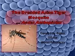
The Dreaded Asian Tiger
by lois-ondreau
Mosquito . aka . Aedes. . Ambopictus. Danny Fox-...
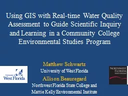
Using GIS with Real-time Water Quality Assessment to Guide
by faustina-dinatale
Matthew Schwartz. University of West Florida. All...
GIS in Water Resources Fall 2011
by natalia-silvester
Groundwater Tools for GIS. Built-in Tools. Time-e...
GIS Mapping of Indiana’s
by pamella-moone
Lake . Michigan Shoreline. Kaitlyn McClain. Coast...
USGS Kentucky Water Science Center
by pamella-moone
Potential . CHIA. application for . WATER. (. W....
Hydro Networks in GIS
by alexa-scheidler
Network model. Flow on Networks. Hydrologic netwo...
Proposal
by conchita-marotz
to contribute to . Freeman . Ranch. Sara . Dunlap...
Proposal
by lindy-dunigan
to contribute to . Freeman . Ranch. Sara . Dunlap...
GIS Based Assessment Effect of Irrigation on Groundwater Level Changes in Agricultural Areas: A Cas
by broadcastworld
Asst. Prof. f. . Dr. . Recep ÇELIK. . Dicle Univ...
ICEWATER: INRA
by sherrill-nordquist
Constellation of Experimental . Watersheds. Cyber...
Impact of Fluoride Concentrations on Natural Waters throughout Texas
by danika-pritchard
Mark . Stehouwer. GIS in Water Resources. Fall 20...
GIS in Water Resources Midterm Review 2018
by cheryl-pisano
Blooms Taxonomy of Educational Objectives. 2. Com...
Utility Technologies, LLC
by yoshiko-marsland
Technology Solutions for Efficient Utilities. Mob...
Hydro Networks in GIS Network model
by bery
Flow on Networks. Hydrologic networks. Linear refe...
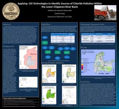
Abstract Applying GIS Technologies to Identify Sources of Chloride Pollution Within the Lower Chip
by megan
Mattheus de . Waard. & David . Leifer. Christ...
District Metered Areas
by ariel297
DMA . creation. . and. management. Contents. Int...
The Dreaded Asian Tiger
by jane-oiler
Mosquito . aka . Aedes. . Ambopictus. Danny Fox-...
Katy Morris: Project Manager
by karlyn-bohler
Nick Down: Assistant Manager. Travis Hamel: GIS A...
GIS – BASED DRASTIC MODEL FOR ASSESSING
by sherrill-nordquist
THE VULNERABILITY OF GROUNDWATER AQUIFERS. TO P...
Remote Sensing and GIS for Hydrology and Water Resources IAHS P, 201(P
by karlyn-bohler
366 Study oan evaluation index system of welloff w...
High Receiving Water Risk Watershed GIS Methodology
by tawny-fly
Objective: To provide guidance for the designation...
Nowcasting Initiative:
by conchita-marotz
User Requirements. Agenda. Introduction. Attendee...
GIS – BASED DRASTIC MODEL FOR ASSESSING
by mitsue-stanley
THE VULNERABILITY OF GROUNDWATER AQUIFERS. TO P...
EEA/ENV seminar 1.June 13
by celsa-spraggs
Beate Werner. WISE and the future of WFD reportin...
Minnesota LiDAR: Minnesota
by danika-pritchard
LiDAR. Wednesday , November 4. th . 2015, 1:00 pm...
What Does MS4 Mean to You?
by danika-pritchard
A study of sewer and storm drain cross contaminat...
Load More...